
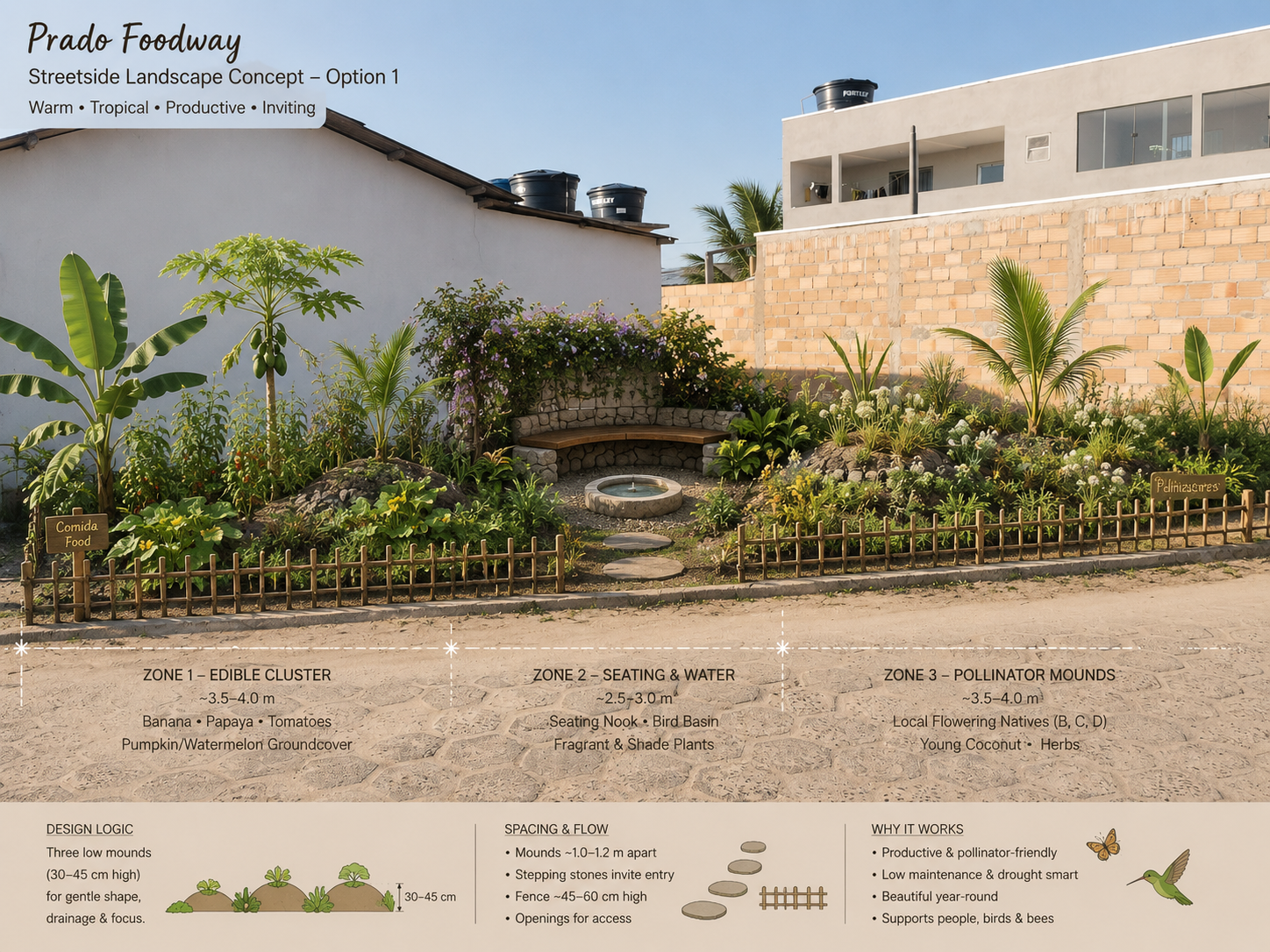
After the Pipe: Can Irrigation Water Keep Working Once It Reaches the Land?
By Sherika Trott Bailey and Kimroy Bailey
On very sandy ground in Prado, Bahia, a family field project is testing a simple extension of water-resilience thinking: after a well and solar pump deliver water efficiently, can roots, mulch, living ground cover and shallow visible water routes help the landscape keep that water useful for longer?
The water-resilience discussion often concentrates on infrastructure before the point of delivery: pumps, treatment, pipes, sensors, storage, energy efficiency and operational visibility. Those systems matter. Asian Water’s recent Grundfos feature made the case that resilience improves when water assets are treated as one connected system rather than a collection of isolated parts [1]. Our family’s field work in Prado, Bahia, begins one step later. We are asking what happens after engineered infrastructure has already done its job and the water reaches the land.
The question emerged from ordinary family work rather than from a laboratory. Sherika Trott Bailey has photographed and filmed the site almost daily, recording wet ground, dry ground, failed plants, new growth, mulch, insects, fruit, shade and the small changes that are easy to forget when a place is seen every day. The record eventually became important for a reason we did not expect: it let us look backward and see the land as a sequence rather than as a single moment.
Prado’s sand made water the first design problem
Our growing area sits in a very sandy coastal environment. In exposed sections, irrigation could disappear from the visible surface quickly, especially during hot, dry periods. Research on sandy soils in Bahia has documented the importance of particle-size distribution and pore structure in determining how much water such soils can retain [2]. Other Brazilian orchard research has found that organic carbon and vegetation cover are associated with better physical quality in sandy soils [3]. Those findings gave scientific context to something we could already see.
Under established trees, the same sandy ground did not look or behave like the open areas. There were layers of fallen leaves, roots, shade, insects, decomposing material and darker near-surface soil. That contrast became the starting point for what we call Life upon Life: preserve useful living material, add productive plants around it, and let each cycle of roots, leaf fall and cover improve the conditions received by the next cycle.
As Kimroy Bailey built the physical planting areas, basins and water routes, the design problem became less about delivering one dose of water to one root and more about creating a landscape that could interact with the water after it arrived.
The well and solar pump move water; the Foodway receives it
The system is deliberately hybrid. We use a shallow well and solar-powered pumping to lift and move water. Solar pumping is already a well-established option in irrigated agriculture, particularly where reliable grid power is limited or where operators want to reduce dependence on fuel-based pumping [5]. From the pump, water can move through a controlled hose or pipe to the growing area.
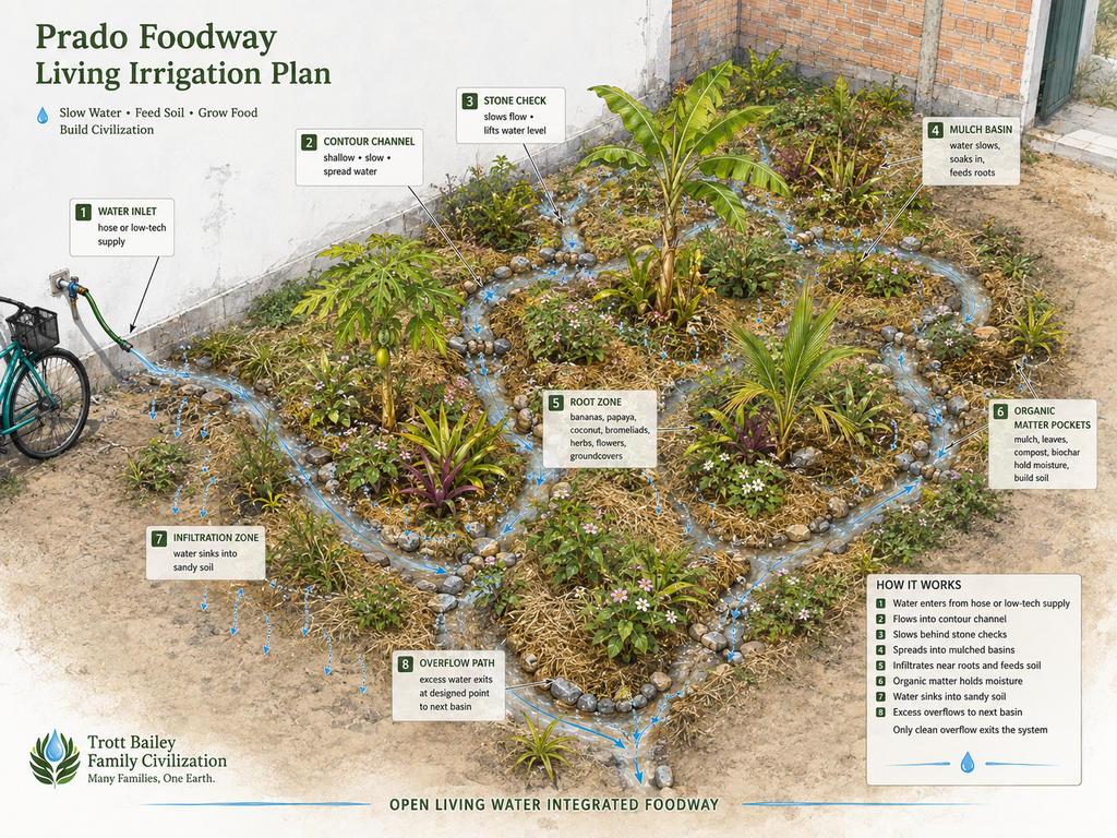
The open component begins only where the controlled supply meets the productive landscape. This is an important distinction. We are not proposing long-distance open conveyance in place of efficient pipework. We are testing short, shallow routes inside the Foodway, where water can slow beside roots, mulch and organic material before infiltrating the sand.
Small stones create check points along the route. Kaleeyon helps set and reset those stones, learning by touch what happens when a gap is too wide or a cluster is too tight. Technically, the stones are not creating high-pressure irrigation. They reduce local velocity, break the energy of the shallow flow and help spread water more gently into nearby basins. A child’s practical adjustment becomes an immediate lesson in hydraulic behaviour: move one stone and the route changes.
We are trying to make the soil part of the reservoir
We call the broader field idea Water with Life. Its central question is whether some irrigation water can do more than reach a crop. A shallow route may also wet leaf litter, support decomposition, cool a small strip of exposed ground, encourage roots toward a repeatedly moistened corridor and help organic material remain biologically active long enough to become part of a better near-surface soil environment.
Mulch is important in this experiment because it changes the soil-atmosphere boundary. A 2024 review of irrigation studies found that mulching can reduce soil evaporation, although the magnitude varies with material, coverage and crop stage [4]. That variability matters to us. We are not treating straw, leaves or ground cover as decorative additions. We want to know which combinations actually extend useful moisture under Prado conditions.
Keilah’s role has increasingly become measurement. She checks and records soil moisture beneath living ground cover and compares it with nearby exposed sandy areas. The observations are simple, but the discipline is important: the family should not call a patch ‘better’ merely because it looks greener. We want to know whether moisture remains available longer and whether the root environment changes with it.
A new habitat appeared around the water
Another change was not on our original irrigation checklist. As shade, mulch, ground cover and damp routes increased, the site began attracting small organisms we had not previously recorded using those dry patches. Kezidek, our youngest, turned this into his own field assignment. Frogs became objects of fascination. Grasshoppers rested in shaded vegetation. Insects moved through the wetter edges while he followed them.
We are careful about what that observation means. The appearance of frogs and grasshoppers does not by itself prove ecological restoration, nor does it measure biodiversity. It does tell us that the microhabitat changed enough for the family to encounter living organisms in places where we had previously recorded mostly hot, open sand. That is now another variable worth documenting rather than an incidental surprise.
The camera became a field instrument
The visual record grew faster than we expected. During the most intensively documented periods, Sherika’s daily photographs and videos, together with images made by the rest of the family, approached roughly 300 media items a day. Across almost a year, ordinary memory was no longer sufficient. There were too many bananas, seedlings, dry patches, watermelon vines, shaded areas, mulch changes and water routes to compare reliably by recollection alone.
Kimroy began treating the archive as another layer of field data. We used Big King Media, a WordPress media system we developed for our own publishing work, to organise the photographs and videos. Automatic alt text added a searchable descriptive layer, while the software’s World Within World groupings helped keep related visual states together instead of allowing them to disappear inside one long chronological archive.
The software did not tell us that a treatment had scientifically succeeded. It did something more modest and useful: it made patterns easier to retrieve and compare. We could move back through time and repeatedly see where bare sand stayed exposed, where living cover persisted, where mulch protected fruit, where water had been routed, where shade increased and where plants recovered after stress. That visual continuity helped us recognise which interventions deserved closer measurement.
In large water systems, operational visibility often comes from sensors and telemetry. At our scale, the photographic archive became a form of field memory. The lesson is similar: a system is harder to improve when its changes cannot be seen over time.
Living water still has to prove its water balance
There is an obvious challenge to an open-water idea: evaporation. A visible route can lose water to the atmosphere. Water can also infiltrate too quickly through coarse sand and move below shallow roots. Poorly arranged channels can erode soil or create unwanted pooling. Water quality can limit where open routing is appropriate. These are not reasons to avoid the experiment; they are reasons to measure it.
Our hypothesis is not that every drop should remain exposed. The pump and pipe should carry water efficiently to the point of use. The experiment begins at that point. We want to know whether a short living route can create enough additional value in moisture distribution, root-zone development, organic-matter cycling, ground cooling and habitat to justify the water it loses.
That means comparing water input against soil-moisture persistence at multiple depths and distances; measuring infiltration; tracking surface and shallow-soil temperature; observing root development; recording organic-matter accumulation; comparing covered and exposed ground; and eventually testing water quality and plant productivity under otherwise similar conditions.
Can irrigation help build a landscape that needs irrigation differently?
The most interesting possibility is temporal. A pipe is designed to perform approximately the same hydraulic task next year. A living route may not. A young Foodway begins with sparse shade, small root systems and limited organic matter. Months later, roots may occupy the wetted corridors. Leaves accumulate. Ground cover thickens. Bananas create more shade. Organic material decomposes. The physical environment receiving the next irrigation is no longer identical to the one that received the first.
That leads to a question we think belongs inside water-resilience discussions: can an irrigation system help build a landscape whose water requirement, distribution pattern or useful storage changes because the biological infrastructure has improved?
We do not yet have a final answer. What we have is a working field system, almost a year of visual evidence, a growing measurement discipline and a family whose roles are increasingly clear. Sherika preserves the daily visual memory. Kimroy builds the physical routes and models the accumulated record. Keilah measures moisture beneath living cover. Kaleeyon adjusts the stones that slow the water. Kezidek notices the creatures that arrive when the ground stops behaving like bare sand.
For us, the central proposition is simple: the pipe gets water to the landscape. Resilience may depend partly on what the landscape is able to do with that water next.
Media note
The Foodway collection contains documentary field photography from Prado. The Living Water collection includes documentary material as well as research visualisations. Some media were enhanced with engineering and modelling tools to reconstruct contextual change in the geography, test spatial relationships, visualise proposed hydraulic behaviour, and communicate research data or hypotheses that cannot be captured in a single photograph. These modelled visuals are not presented as literal documentary evidence. They are analytical representations of observed conditions, design intent and testable hypotheses, and should be captioned accordingly if reproduced.
References
[1] D. Leathley, “Water Infrastructure Resilience Requires Integrated Approach,” Asian Water, Aug. 31, 2026. [Online]. Available: https://asianwater.com.my/water-infrastructure-resilience-requires-integrated-approach/
[2] R. da B. V. Parahyba, M. do S. B. de Araújo, B. G. de Almeida, F. C. Rolim Neto, E. V. S. B. Sampaio, and A. M. Caldas, “Water retention capacity in Arenosols and Ferralsols in a semiarid area in the state of Bahia, Brazil,” Anais da Academia Brasileira de Ciências, vol. 91, no. 4, e20181031, 2019, doi: 10.1590/0001-3765201920181031.
[3] J. Fidalski and C. A. Tormena, “Physical quality of sandy soils under orange orchards in Southern Brazil,” Revista Brasileira de Ciência do Solo, vol. 46, e0220006, 2022, doi: 10.36783/18069657rbcs20220006.
[4] T. B. Ramos, H. Darouich, and L. S. Pereira, “Mulching effects on soil evaporation, crop evapotranspiration and crop coefficients: a review aimed at improved irrigation management,” Irrigation Science, vol. 42, pp. 525–539, 2024, doi: 10.1007/s00271-024-00924-8.
[5] M. Salman, A. Abdelfattah, W. Ahmad, and C. Simongini, The Use of Solar Energy in Irrigated Agriculture: A Sourcebook for Irrigation Water Management with Alternative Energy Solutions. Rome, Italy: Food and Agriculture Organization of the United Nations, 2022. ISBN 978-92-5-135699-9.
Author Bio
Sherika Trott Bailey and Kimroy Bailey are Jamaican-born family systems authors and technology developers working from Brazil. Their Prado field work documents sandy-soil behaviour, mixed food planting, water routing, organic matter, family participation and long-term visual observation. Sherika leads much of the project’s daily photographic and video record. Kimroy develops the physical Foodway systems and the software-assisted methods used to organise and compare the accumulated media record. Together they developed the Life upon Life and Open Living Water field frameworks as practical questions to be observed, measured and refined rather than as finished scientific claims.
Declaration of Relevant Interests
The authors are the creators of Big King Media, the WordPress media-management software mentioned in this article. Big King Media is provided free. It was developed initially to solve the family’s own large-scale media-management problem and was used in the Prado project to organise and retrieve the field photograph and video archive. Its inclusion here reflects its documented role in the observational workflow. There is no paid placement, affiliate relationship, or product recommendation associated with this article, and no link to Big King Media is included in the article. The software’s use did not determine the scientific interpretation of the field observations; it helped the family organise, retrieve and compare the visual record from which questions for further measurement were identified.